GeoImaging Tools 1.0

Provides users a suite of tools for processing and analyzing imagery in the GIS
Rating
Your vote:
Latest version:
2.0 See all
Developer:
Screenshots
1 / 1
Awards (1)
Show all awards
Software Informer Virus Free award
Download

No specific info about version 1.0. Please visit the main page of GeoImaging Tools on Software Informer.

Comments

User

Your vote:

Related software

Color Correction Wizard
Free
rating

It can correct the color and the contrast of our photos.

Vixelsoft Imaging Express
rating

Imaging Express handles Windows imaging documents as well as Kodak files

Batch AutoCorrector
Batch AutoCorrector
Free
rating

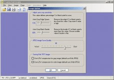
Batch AutoCorrrector is capable of improving a batch of images in one go.

MShot Digital Imaging System
Free
rating

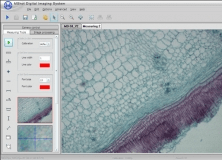
It allows you to view, capture, measure and process microscope images.

Imaging Toolkit for Delphi
rating

Collection of VCL components.

Tags

Data Sensor Correction Reducing Duplication